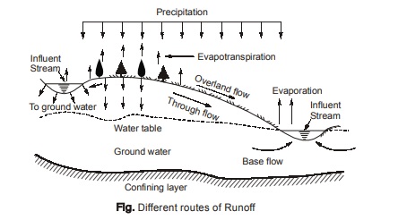
What are the components of the runoff?
Various components of runoff are as explained below:
1. Overland Flow : Consider a catchment area having precipitation of a considerable intensity and duration. If depth of precipitation is so much that it can compensate for the losses such as evapotranspiration, initial loss, infiltration and storage requirement etc. and still some depth of precipitation is left, then it will reach outlet in form of runoff. After covering all the losses, the excess precipitation that moves over land surfaces to reach small channels of catchment, then the flow is known as overland flow as shown in figure.

Overland flow involves building up of a storage over the surface and draining off the same. Overland flow is generally small in volume and it is in laminar regime.
2. Surface Runoff : In bigger channels, flow comes from various small streams and flow in these bigger channel combine to form on a bigger stream that eventually reaches the outlet of catchment. This flow is known as surface runoff which travels all over the time over surface as overland flow and through the channels as open channel flow and finally reaches the outlet.
3. Interflow : Some part of infiltrating precipitation moves in lateral directions through upper crust of soil and return to surface at some location away from point of entry into soil. This component is known as interflow, through flow, storm seepage, subsurface storm flow or quick return flow. Its volume depends on conditions of catchment. Its volume will be large in a fairly pervious soil overlying a hard impermeable surface. It is sometimes divided into
-
- Prompt interflow, i.e., flow with least time lag
- Delayed interflow
4. Ground Water Runoff : Some part of infiltered precipitation can also undergo deep percolation and reach ground-water storage in soil. As the ground water follows a complicated and long path of travel, therefore, time lag, e., difference in time between entry into soil and outflow from it is very large. This part of flow is known as groundwater runoff or groundwater flow. This flow provides dry weather flow in perennial streams.
Limitations of Unit Hydrograph
- Unit hydrograph assumes uniform distribution of rainfall over the catchment, and the intensity of rainfall is assumed constant for the duration of rainfall excess. In practice these two conditions are never strictly satisfied.
- Unit hydrograph method cannot be used for a catchment area greater than 5000 km2 and less than 2 km2.
- Precipitation must be from rainfall only. Snowmelt runoff cannot be satisfactory represented by unit hydrograph
- The catchment should not have large storage (Ex: tank pond etc. ) which affects the linear relationship between storage and discharge.
In the use of unit hydrograph 20% variation in time base and 10% variation in peak are expected in reproduction of result.
<< Previous | Next >>
Must Read: What is Hydrology in Civil Engineering?


